 Rob Hall (GM Southern NZHPT) has generously provided us with a copy of the (Heritage) PowerPoint Presentation he gave to the Christchurch City Council Earthquake Recovery Committee of the Whole (Council) on the 12th February 2014.
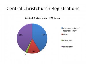
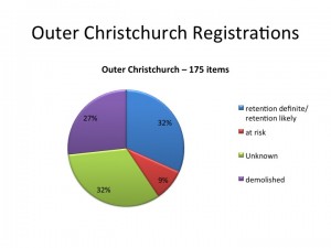
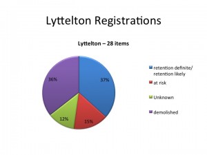
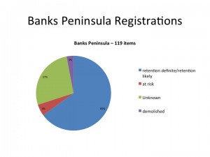
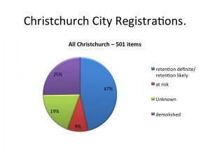
The PowerPoint (converted to images) includes pie chart diagrams that illustrate the proportion of registered heritage buildings lost and those that are still at risk.
The PowerPoint has been converted to images and the presenters notes accompany each slide.
Click on each image to enlarge.
Notes for Slide 1:
Good morning Mayor, Councillors and thank you for taking the time to hear us today.
For those of you that I have not met, my name is Rob Hall – I am the General Manager, Southern region of the New Zealand Historic Places Trust. I have with me today, Dave Margetts and Mike Vincent.
I hope you all have copies of a Report we have produced for you , which we provided to your staff two weeks ago.
Notes for Slide 2:
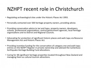
1.NZHPT is an autonomous Crown entity that is approximately 80% funded by the Crown through the Ministry for Culture and Heritage. We operate under the requirements of the Crown Entities Act and the Historic Places Act.
2. The organisation is governed by a Board mostly appointed by the Minister for Arts, Culture and Heritage, and incorporates the Maori Heritage Council. As an autonomous Crown Entity it is not subject to direction by the government on matters of heritage policy.
3. Immediately after the 2010 earthquake event, NZHPT staff set about contacted over 500 heritage property owners to provide free expert heritage and structural engineering advise. We have also been providing heritage assessments and individual Reports to CERA and the CCDU to inform their decision making in respect of them exercising Section 38 of their Act.
4. Our normal and ongoing role is to assist in the long-term survival highly significant heritage places, wahi tapu, wahi tupuna and archaeological sites by:
Notes for Slide3:
These figures are based on the current situation measured against the NZHPT register, just prior to the earthquakes. They therefore differ to the CERA Reports, which use July 2012 as a baseline to measure back to.
Christ Collage and Arts centre sites represent about 20 registered sites, so these figures can be a bit misleading.
Notes for Slide 4:
This graph shows the area outside the four avenues, but not including Banks Peninsular or Lyttleton
Notes For Slide 7:
Summary of all of Christchurch


Comments are closed.